Back هارولد وود AZB Harold Wood CEB Harold Wood Basque هارولد وود Persian Harold Wood French Harold Wood Irish Harold Wood Dutch Harold Wood Polish Harold Wood Swedish ہیرولڈ ووڈ Urdu
| Harold Wood | |
|---|---|
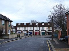
 Terraced housing at Queens Park Road | |
Location within Greater London | |
| Population | 12,650 (Harold Wood ward 2011)[1] |
| OS grid reference | TQ545905 |
| • Charing Cross | 16.5 mi (26.6 km) WSW |
| London borough | |
| Ceremonial county | Greater London |
| Region | |
| Country | England |
| Sovereign state | United Kingdom |
| Post town | ROMFORD |
| Postcode district | RM3 |
| Dialling code | 01708 |
| Police | Metropolitan |
| Fire | London |
| Ambulance | London |
| UK Parliament | |
| London Assembly | |
Harold Wood is a suburban neighbourhood in East London in the London Borough of Havering. It is situated 16.5 miles (26.6 km) east-northeast of Charing Cross. Harold Wood was part of the ancient parish of Hornchurch, which became the Liberty of Havering. Most of the current area of Harold Wood became part of Hornchurch Urban District in 1926. It is near to the Greater London boundary with Essex.
- ^ Census Information Scheme (2012). "2011 Census Ward Population figures for London". Greater London Authority. Retrieved 17 October 2023.
© MMXXIII Rich X Search. We shall prevail. All rights reserved. Rich X Search
